Maps
To report an issue on Bolton’s Trails click here. Bolton Trails Committee records problems using Trailcare.com.
Summit series challenge is now closed.
Find the map you need on this page
From a computer click on the area using the map.
From a mobile device use the table.
For all the trails in town click here.
Click here for a selection of files for use with GPS apps on mobile devices in .kmz format. For instructions on how to use .kmz files click here.
If you are interested in history, here’s a look at Bolton’s layout in the 1800s: 1831 map, surveyed by Silas Holman
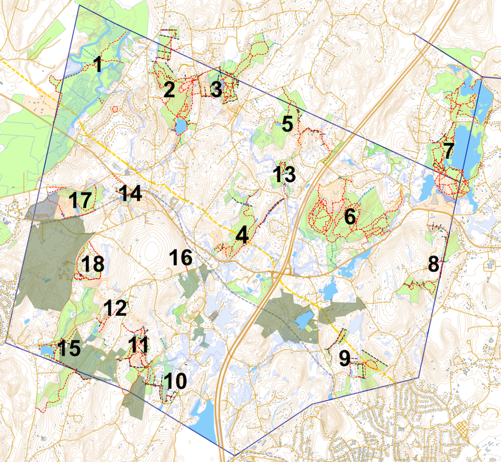
| # | Area – click for map detail | Acres | Parking and Access: Latitude, Longitude (enter the numbers into your map application for directions) |
|---|---|---|---|
| 1 | Bolton Flats Wildlife Management Area | 455 |
42.469058, -71.630303. Still River Rd. Car top boat launch and seasonal access to trails west of the river. 42.460556, -71.637333. 0.6 miles north of the traffic lights on Still River Rd. Appropriate for kayaks and canoes; very few trails are accessible from here car top boat launch a few yards from the parking area. 42.457500, -71.648806. 0.35 miles west of the traffic lights on Route 117, just west of the Lancaster boundary . Offers the most opportunities for walkers. 42.461389, -71.656972. 0.82 miles west of the traffic lights on Route 117 (0.5 miles west of the Lancaster boundary). Nashua River Boat Launch. Suitable for canoes and kayaks. No access to the trail system. |
| 2 | Vaughn Hills | 100 |
42.467139, -71.625472. Vaughn Hill Road. Moen Parking area and kiosk. 4 cars. |
| 3 | Bowers Springs | 91* |
42.462750, -71.603917. Flanagan Road. 14 cars NOT in entryway or exit area. Do not park on Flanagan Road. |
| 4 | Powder House Hill, Old Town House Road, Town Common and Evans Trails | 79 |
42.433417, -71.605139. 2 Cars Behind the Town Hall (663 Main Street). 42.434139, -71.609722. The Town Common 42.444356, -71.591871. The Garrison House. 1 car. 42.446083, -71.598139. Quail Run Road. 2 cars parked on the shoulder near the trailhead. |
| 5 | Zink-Northwoods | 104* |
42.453000, -71.580278. Corn Road. 1 or 2 cars on the shoulder. |
| 6 | Rattlesnake and Vicinity | 438 |
42.438333, -71.566250. Main St. 8-9 cars. 42.445752, -71.563310. Harris Farm Circle. 2 cars along the roadway shoulder. NOT on the private driveway. 42.448361, -71.578556. Junction of Sugar Road and Old Sugar Road. 4 cars on the shoulder. |
| 7 | Delaney Wildlife Management Area | 580* |
42.458333, -71.549861. Finn Road, Harvard (either side of the Road). 42.450917, -71.543417. Harvard Rd, Stow (Car Top Boat launch). |
| 8 | Annie Moore | 118* |
42.428528, -71.563139. Annie Moore Road. 1-2 cars on the roadway shoulder. 42.439559, -71.556966. Bolton Woods Way Trailhead, 1-2 cars. |
| 9 | Danforth Brook and Keyes Farm | 83 |
42.412278, -71.576111. On Danforth Lane. 2 cars. Note that parking space at the cul-de-sac is reserved for emergency vehicles. |
| 10 | Vinger-Venable and Rocky Dundee | 66 |
42.415111, -71.624306. Intersection of Randall Rd and Rocky Dundee Rd on a grassy shoulder. 4 cars. 42.408889, -71.618306. Quaker Park, on shoulder not blocking the road. 1 car. 42.413278, -71.626694. East side of Randall Rd. 1 car. |
| 11 | Gould-White | 48 |
42.415111, -71.624306. Intersection of Randall Rd and Rocky Dundee Rd on a grassy shoulder. 4 cars. 42.413278, -71.626694. East side of Randall Rd. 1 car. |
| 12 | Welch Pond | 11 |
42.423278, -71.637750. Wattaquadock Hill Road – Gould Memorial trail head. 3 cars. |
| 13 | Houghton Farm | 1.0 |
42.447013, -71.591709. Houghton Farm Lane shoulder next to the trail head sign. 2 cars. |
| 14 | Wilder Farm | 11 |
42.446005, -71.629698. Main Street/Route 117. 2 cars. |
| 15 | Fyfeshire and Haynes-Wheeler Conservation Areas | 38 |
42.418278, -71.648972. Wattaquadock Hill Road at the Fyfeshire entrance gate. 6 cars parallel parked. |
| 16 | Bolton Overlook | 4.5 |
42.431556, -71.615250. Wattaquadock Hill Rd, gravel parking area. 3 cars. |
| 17 | Taggart | 43 |
42.446957, -71.638602. Forbush Mill Rd, On the edge of the roadway. 2 cars 42.446366, -71.645595. Morse Sawmill Dam, on the edge of the roadway. 2 cars. 42.446508, -71.650129. Forbush Field. Large parking area next to soccer fields. |
| 18 | Ballville Trails | 30 |
42.4364639,-71.6404676. Ballville Rd., 4 cars at The Oak Trail Circuit trailhead near the turning into the housing development. 42.4307448,-71.6437332. Ballville Rd. 5 cars at the point where the trail crosses a fire access track close to the paved road. |
*A portion of total acreage is outside Bolton.
The Bolton Conservation Trust, the Conservation Commission, and the Trails Committee would like to thank all those who have cleared, maintained, and cared for our trails and conservation lands, helping to keep them open and accessible to everyone.
Bolton’s trails weave through our community, and offer us all a place to pursue any number of outdoor activities. Most of the town’s trails are on public conservation lands, many of which have been acquired through the generous donations of Bolton citizens. Numerous trails traverse some portion of private land, however, and we are grateful to those landowners who generously share their properties through trail easements and informal trail crossings.
More information can be found on this site by searching the Get Outside drop down menu.
Click here for a selection of files for use with GPS apps on mobile devices.