18 Ballville Trails
For a high resolution map click here:
Size: 30 Acres
Access: From Ballville Road near the turning in to the Oak Trail housing development. Coordinates 42.436445, -71.640375 (251-267 Ballville Road), also south along the road at the next trailhead: 42.435278, -71.641389 (263 Ballville Road) and again further south at the point where the trail crosses a fire access track close to the paved road at 42.430738, -71.643489.
Parking: 42.4364639,-71.6404676. Ballville Road, 4 cars
42.4305643,-71.6437862, 5 cars
Description: There are two parcels of conservation land in this area. Both were acquired by the Town of Bolton in 2008 when the Oak Trail Farming and Open Space Residential Development was subdivided. There is also a trail easement owned by Bolton Conservation Trust which crosses private property at the north edge of the housing development next to a large meadow associated with Townshend Farm.

Ballville: Families called Ball lived in this area before 1790. A neighborhood called Ballville appeared on a map in 1998. In 1831 two people named W Ball were still living adjacent to each other on what is now Ballville Road close to the intersection with Sawyer Road.
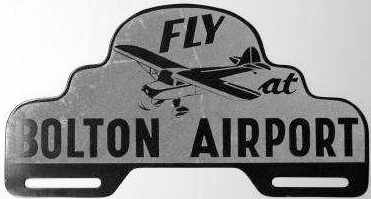
Bolton Airport: This part of town is now known by most residents as the location of The International Golf Course, but although there has been golf on the site since Runaway Brook Golf Club was built in 1899, nearby was the location of Bolton Airport which operated from 1932-1952. It started as Clinton Airport and reopened as Bolton Airport at some time during 1942-1943. The entrance was at the intersection of Ballville and Wilder Roads. A significant part was on what is now the Twin Springs golf course on Wilder Road. For more information and videos of aircraft taking off and landing, search for “Bolton Airport Massachusetts” on the internet.