Five Natural Oddities You Can Find Outdoors in Bolton
May 19, 2021
The Bolton Trails Committee wasn’t upset that some of Bolton’s natural features were excluded from Boston Magazine’s recent article, Five Natural Oddities You Can Find Outdoors near Boston by Kaylyn Yee but thought we should take a crack at our own list below.
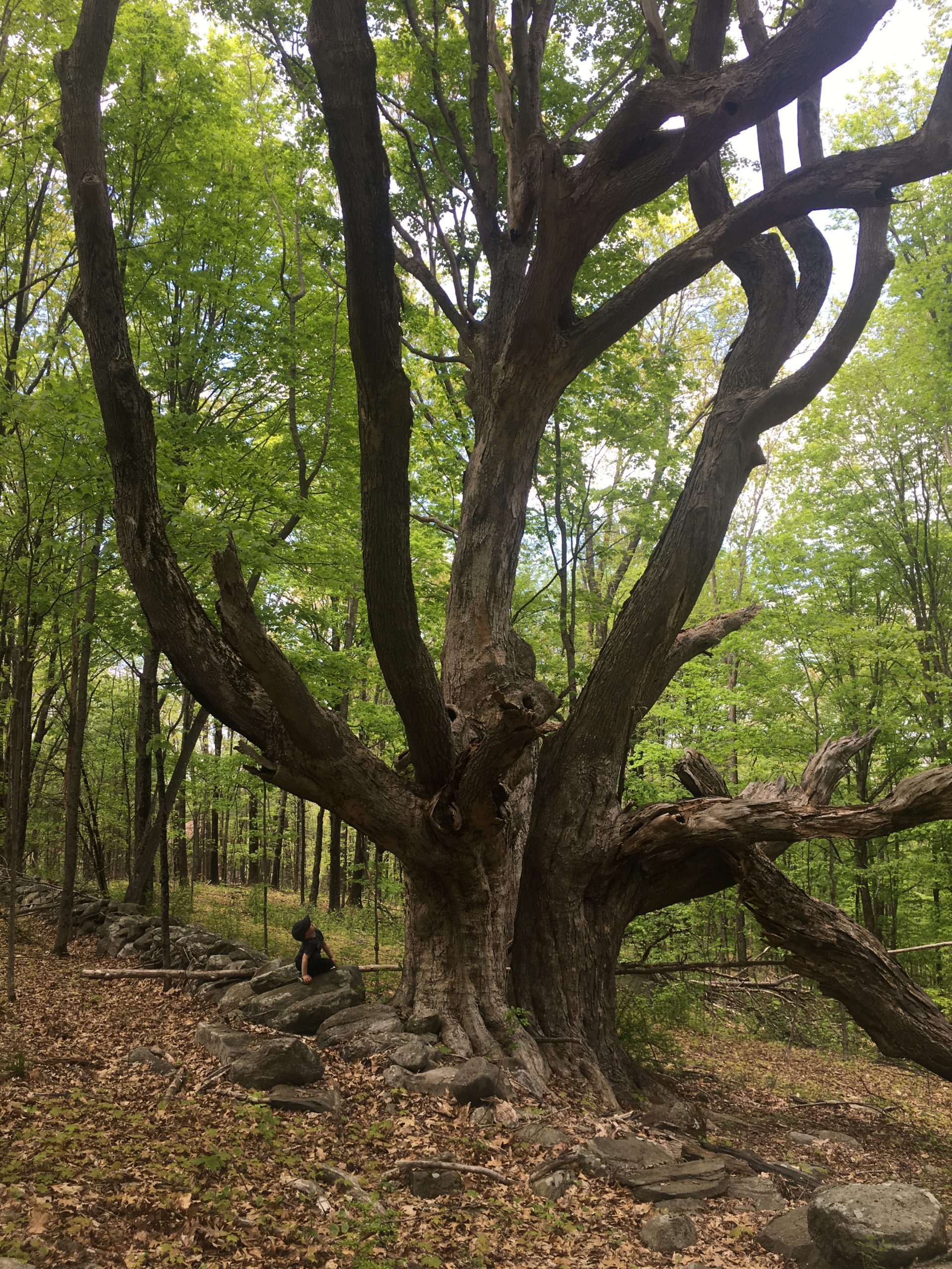
(1) Barrett’s Hill Wolf Tree
Property: Danforth Brook
It would be difficult to find a wider tree in Bolton. This wolf tree (a forester’s term for a tree that takes more than its share of space) has found a comfortable location on the top of Barrett’s Hill for quite a long time. Like other wolf trees in the area, it has likely avoided lumber harvesting due to its inaccessiblity from roads and proximity to a stone wall. It is quite the climb up Barrett’s Hill from the parking area on Danforth Lane, but worth the visit to see such a lovely maple specimen. A more gradual ascent to the summit of Barrett’s Hill is noted on the Danforth map of the Bolton Trails Guide. Once at the summit, follow the stone wall heading northwest until you reach the tree. While visiting, don’t forget to admire the antique car graveyard, located along the gas pipeline trail easement.
Bonus: Head toward the North Meadow in Bowers Springs to view another wolf tree with some fairly low (kid height) branches. And of course, be sure to admire the allee of Norway spruces on the way to the lower ponds.
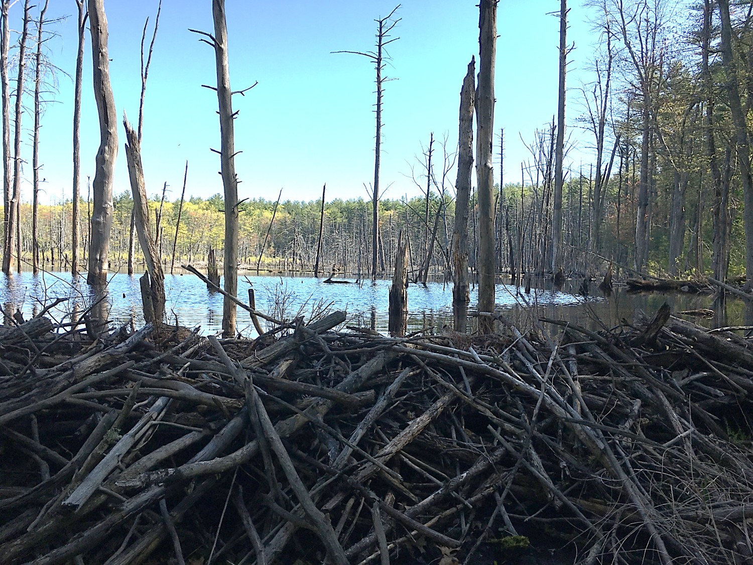
(2) Beaver Pond Dam
Property: Vaughn Hills
Beavers, the engineers of the animal kingdom, have transformed the habitat of this conservation area using just mud and sticks. The busy beavers have limited the water flow downhill, leading to a pond that seems to grow in size every year. This enlarged pond has created an ideal habitat for many other wildlife, including ducks, muskrats, herons, and osprey. What makes this beaver pond unique is that the trail passes right below the dam. To view this natural engineering marvel, a short walking loop can be formed around the pond starting at the entrance on Green Road.
Bonus: There are other beaver ponds throughout town conservation areas, including Bowers Springs, Houghton Farm, Welch Pond, and Wilder Pond.
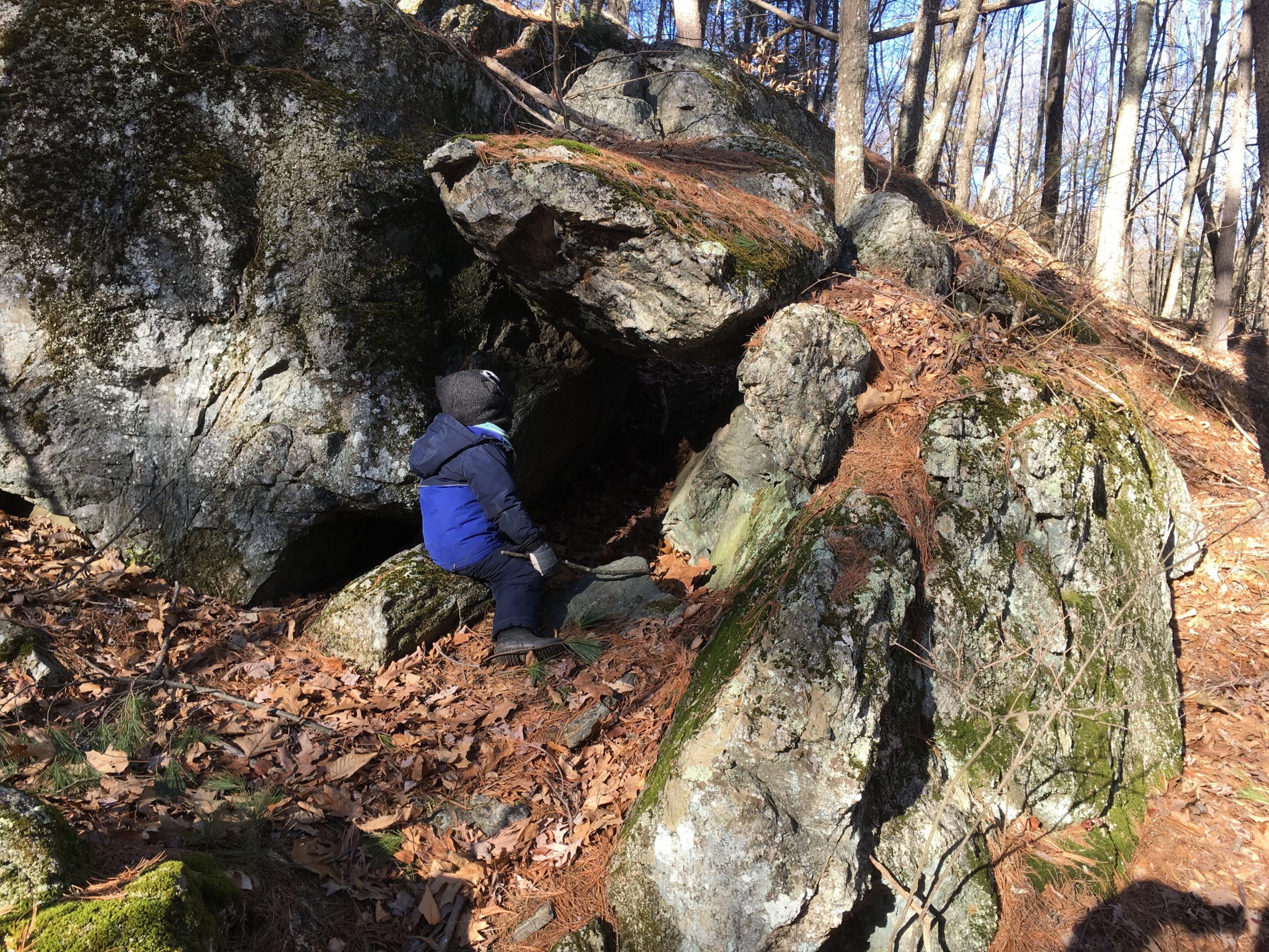
(3) The Cave
Property: Gould-White
The rocks here managed to orient themselves in just the right way to make a perfect crawl-through cave ideal for youngsters and flexible adults. This “natural playground” of sorts is tucked away in the middle of the Gould-White property. Head toward Point of Interest #1 on the Gould-White map. Park at the intersection of Rocky Dundee Rd. and Randall Rd. or the solo parking spot further down Randall Rd. and head up the Basin Loop Trail. It’s a short walk from either parking area (~1 mile).
Bonus: While you are there, you may want to check out some of the other natural features in the area, like the wetland pond on the way to “The Cave” or the “Filtered Forest” a little farther north. If you like cavernous features, there are several abandoned mines resembling caves at the Rattlesnake conservation area along the Lime Kiln and Quarries.
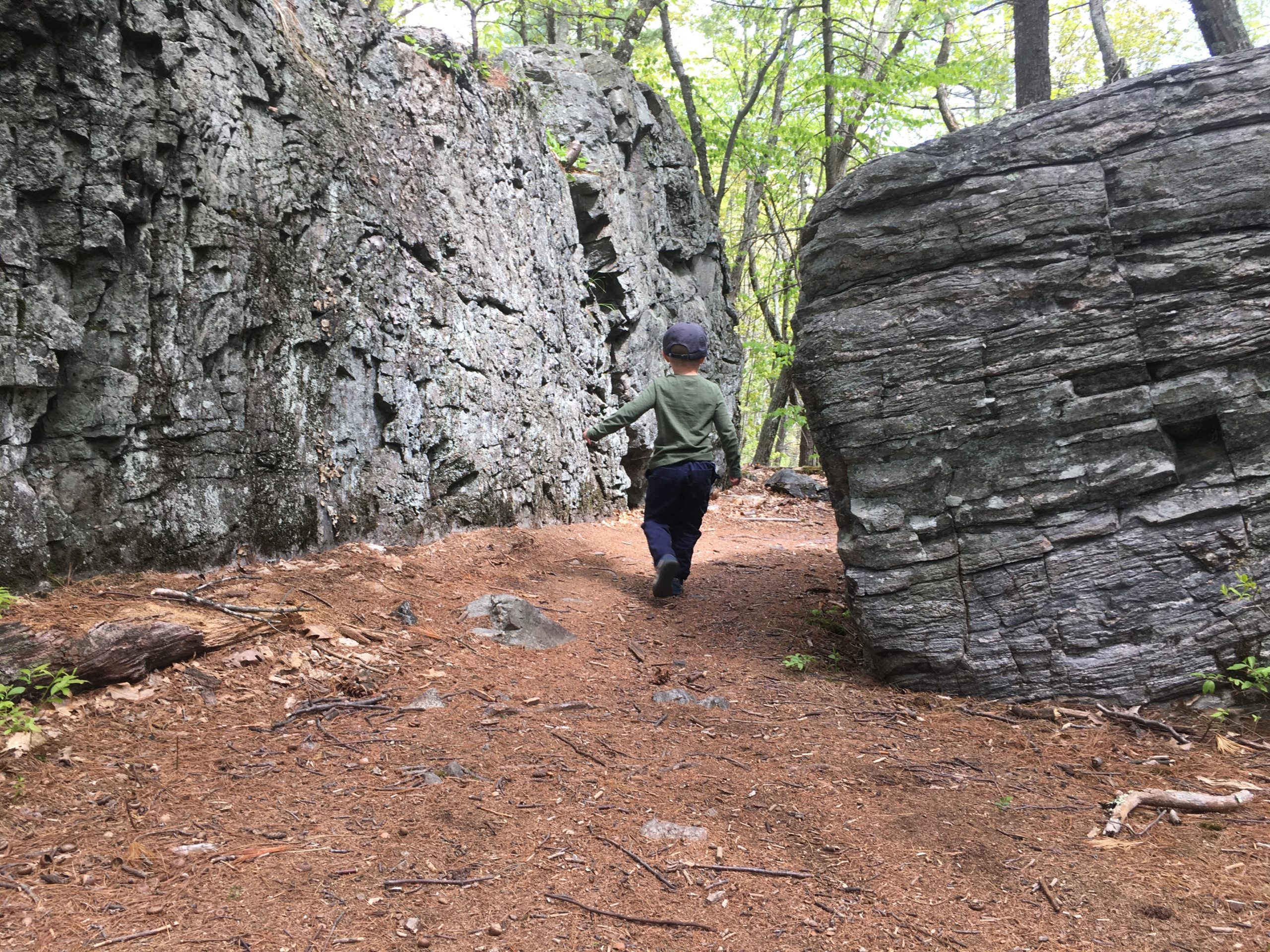
(4) Split Rock
Property: Rattlesnake / Split Rock Trail
This odd feature is hard to miss, as the trail goes right through the center of the split boulder. This boulder must have separated a long time ago, as the sides are weathered and the trail well-worn. To get there, park at the end of Old Sugar Rd. at Trailhead #3 (TH3). Follow the Split Rock Trail south for about 1 mile. It is noted as Photo #2 on the Rattlesnake West map.
Bonus: If looking to create a loop, try to include the Park Bench trail for a nice pastoral view, which not surprisingly has a shaded bench available to enjoy the view of the meadow.
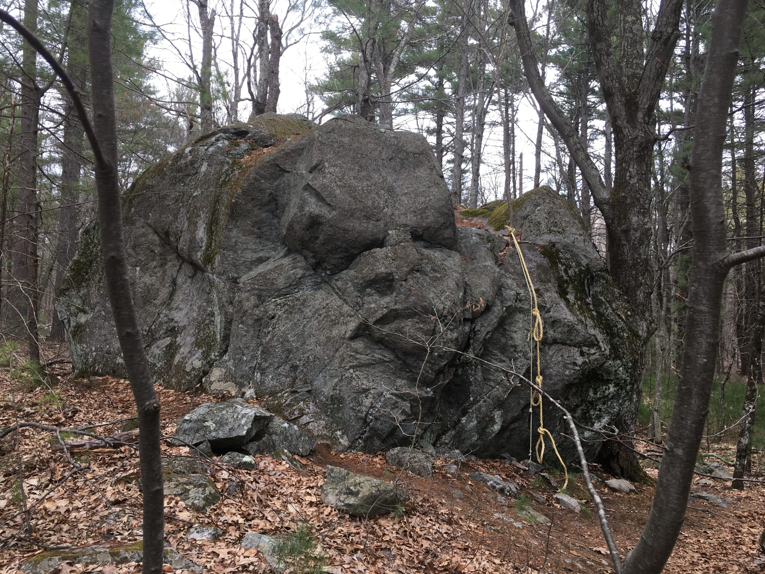
(5) Zink Boulder
Property: Zink-Northwoods
There is not much more to say, but “that is one big rock.” Not quite as large as a house, but certainly an impressive size for this glacial erratic, which is a large rock moved by glacial activity. Sit on the log bench nearby as you take in its size and consider how out of place it seems, including as a part of the adjacent stone wall. Since stone walls were often used as a form of fencing, especially during the mid-1800s for the “sheep fever,” it made sense to include this impenetrable boulder as part of the stone wall enclosure.
When approaching the boulder from the south, some say you can make out a human face in the rock. Can you see it? It’s about a 3/4 mile walk meandering along the stream from the parking area along Corn Rd. Just head toward Photo #2 on the Zink-Northwoods map. Parking is available along the road near the private driveway adjacent to the culvert over the stream; please don’t block the driveway.
Bonus: Glacial erratics are all over our conservation areas, including some impressive ones in the Rattlesnake conservation area by intersection 2K and the Powder House conservation area close to the Quail Run trailhead. Also to be explored are kettles, other geologic features that formed when a block of ice detached from a glacier, becoming fully or partially buried in the sediment, melting away, and leaving behind a depression. This can either fill with water (ex. Welch Pond) or, if the soil is sandy enough to avoid filling with water, leave a noticeable depression, like the Kettle Hole conservation area of Kettle Hole Rd.
Do you think another unusual natural feature should have been on this list? Feel free to send us an email: info@boltontrails.org